

Snow extent this year is much higher than average and according to existing global measurements it is at the highest point which has been observed since 1966.
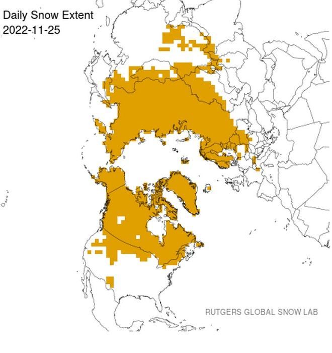
Specifically, the extent of snow in the Northern Hemisphere reaches approx 41 million square kilometers, according to the NOAA/Rutgers Global Snow Lab. The latest snow cover information is given in the image below which shows the extent of snow in the Northern Hemisphere.
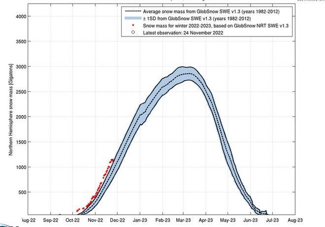
At the same time, the weekly extent of snow cover in the Northern Hemisphere is high for the winter season 2022-2023 and is shown below in purple , along with the average (gray dashed line), maximum (blue) and minimum (orange) snow cover extent for each week.
Mean weekly snow cover extent and extremes were calculated using the period of 56 years from October 1966 until July 2022.
Also looking at the map below from Rutgers Daily Snow Extent, it is immediately apparent how Russia is currently completely covered in snow.
Snow is also observed to have overwhelmed all of Canada and Alaska, as well as much of the 48th parallel. It is the largest area of snow in decades. In Eurasia, huge areas with more snow cover exist especially in Eastern European countries as well as in Russia and Central China. In North America the extent of snow for the end of November is further south than normal, especially in the Northwest and Northeast sectors of the US.
According to the Finnish Meteorological Institute, the total snow mass for the Northern Hemisphere this season is comfortably above the 1982-2012 average. This result is based on the current Northern Hemisphere snow-water equivalent relative to the long-term mean and variability.
The extent of the snow has grown quite rapidly in the last 30 days, as should generally be the case at this time. The widespread extent of snow early in the season is an indicator of persistent cold as we head into winter, largely due to the albedo feedback.
Will it keep cold or not?
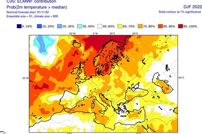
According to the latest forecast data, Europe presents warm anomalies in the central and northern parts. Looking at the forecast for surface temperature probability over Europa, we see a warmer pattern. Most of the continent is in the warmer sector. However, average temperatures are more likely in the western/southwestern parts for the next quarter (Dec-Feb).
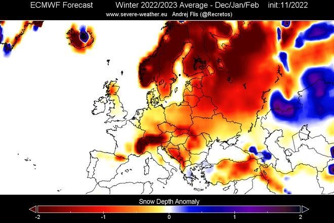
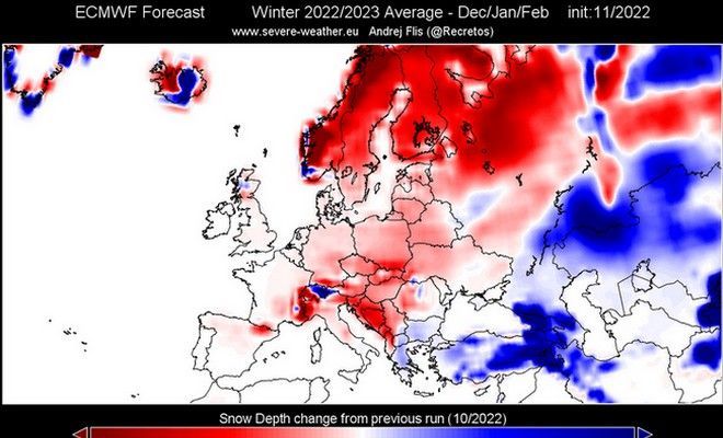
In Europe, we are seeing below average snowfall across most of the continent. It is noted that this does not mean that there will be no snow, but simply indicates less snowfall than normal. In our country and in parts of Bulgaria and NW Turkey, prices appear a little higher than normal, but the deviation is not significant.
The next image below shows the change in snow depth forecast between the model’s latest data and its previous run in October. We can see that the latest ECMWF forecast shows less snowfall across most of the continent, compared to his previous run. Slightly higher prices are presented in central and northern Greece, Bulgaria and North Macedonia (Skopje). The discrepancies in Eastern Turkey are very high.
Can predictions be changed?
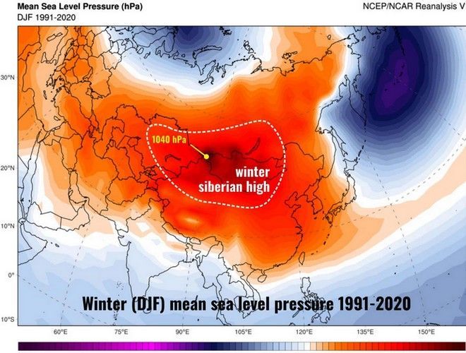
The forecast data show great uncertainties from December onwards, in contrast to the good predictability they showed in the autumn months. As “strange” as it may seem to us, the Siberian High could strongly influence the weather in western Europe, especially when retrograde flows occur which create unusually cold conditions in the “old continent”.
In the image below we can see an example from the beginning of February 2012 when such a historic cold outbreak affected Europe and the Mediterranean, while we had a similar system in November 2022. The air mass moves in the low troposphere and consists of very cold, dry and dense air.
The Siberian High is defined as a surface anticyclone that formed due to downward motions within the tropospherethat is, the atmospheric layer where weather occurs
It is worth noting that numerous studies have recently found an unexpected phenomenon of extensive autumn and winter cooling in central Eurasia that does not fully reflect the nature of climate variability over time. A team of scientists has shown how autumn cooling in Eurasia is likely influenced by the Pacific Decadal Oscillation (PDO) and the Siberian High (SH). Since 2004, the strengthening of SDO and SH explains about 54% and 18% of the autumnal cooling in Eurasia, respectively.
The relationship between autumn snow cover and subsequent winter temperatures is generally much stronger for Eurasia than for North America. For Eurasia, the mean extent of snow cover during autumn explained up to 52% of the variation in winter (December–February) temperatures compared to only 12% for North America. However, when mean winter snow cover is correlated with mean winter temperature, the relationship is better for North America than for Eurasia. 46% of the winter temperature variation is explained by winter snow cover in North America compared to just 12% in Eurasia. This is because the extensive snow cover in North America lowers the surface air temperature directly through local diabatic cooling.
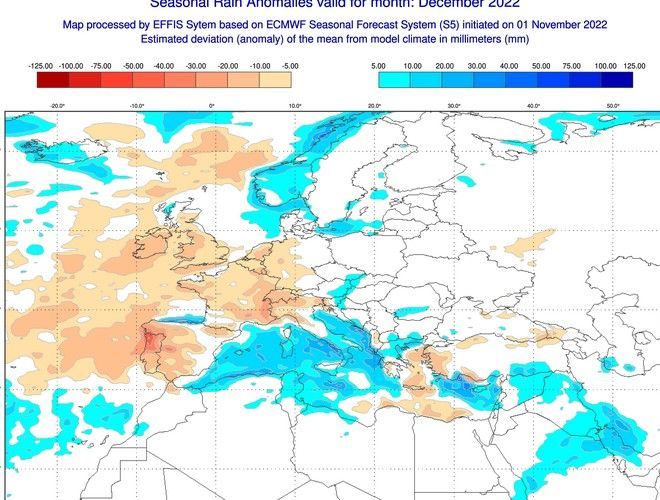
Before we close, let’s also refer to the rains in December, where there is a tendency for all the Mediterranean countries to have a lot of rain, with central and southern Italy receiving the highest amounts of rain. In our country, the Ionian, the western central and northern continental regions will have rains above normal levels. In the Eastern island country the rains will be at levels slightly below normal levels, while in the Dodecanese they will be increased. In a week from today we will have the new model runs available and present you with an updated weather trend.
Follow News247.gr on Google News and be the first to know all the news
Tags: snow Northern Hemisphere years
-


