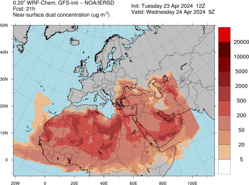
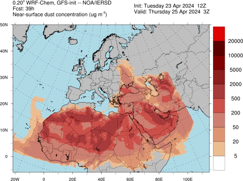
Another day with the “Minerva red” phenomenon, i.e. the African dust, covering most areas of the country, especially in the south.
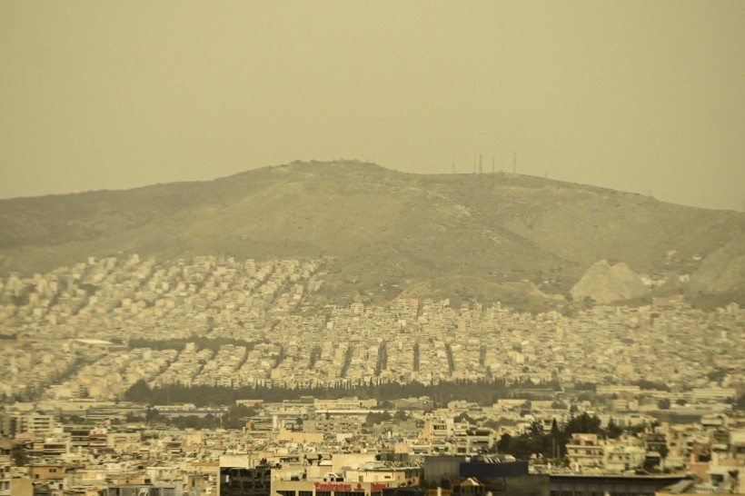
With the “good morning” Athens is on Wednesday morning “choked” in an intense and suffocating layer of dust, while in Thessaloniki the phenomenon has begun to recede.
Experts reiterate the danger to health, due to the high concentration of fine particles in the air, while meteorologists predict that the phenomenon will gradually subside today starting from the west.
Watch video with the image of the sky above Attica on Wednesday morning:
It is recalled that on Tuesday the African dust mainly covered the southern continents, while there were also mud showers in some places.
Apart from the African dust, very high temperatures were recorded in areas of Southern Greece and especially in Crete, where the highest temperature was recorded in Falasarna of Chania with a value of 36.6°C.
As can be seen in photos and videos from Attica, an orange veil covered the basin yesterday, with the area around the Parliament and the Acropolis covered in dust.
See the transport of African dust to Athens:
The eerie scene was also captured in a post by the meteorologist, Kostas Lagouvardou, on Facebook. Uploading a photo from the Observatory in Penteli, he writes in his post: “Our colony on Mars”.
When will the dust settle
An answer to the question of when the African dust will leave the country is given by Elina Karetsou, with her post on Facebook, with Athens and other areas reminiscent of the Sahara.
The meteorologist of flash.gr emphasizes that the strong episode of African dust affecting the country will begin to recede from Wednesday, April 24, while she explains how the impressive and potentially dangerous meteorological phenomenon was created.
The evolution of the phenomenon until April 25


The evolution of the weather according to the EMY
According to the National Meteorological Service (NMS), the transport of African dust affecting our country will gradually begin to decrease from today, Wednesday, in the morning. However, it is pointed out by EMY that a significant decrease in concentrations is predicted from midday onwards, when it will be limited to the east.
In particular, in the western and northern continental areas, temporarily increased clouds are predicted with a few local rains. Isolated storms will occur in the northwest in the early hours of the morning and again in the night, while locally limited visibility is forecast in the continental areas in the morning hours.
Winds will blow from the west at 4 to 6 Beaufort. In the eastern island country winds will initially be SE 7 to 8, but will quickly weaken and turn to S SW 3 to 5 and in the south 6 locally to 7 Beaufort.
The temperature will drop slightly mainly in the west.
Detailed EMY forecast until Palm Sunday
MACEDONIA, THRACE
Weather: In Western Macedonia temporarily increased cloudiness with rain and possibly isolated rain in the mountains until the morning hours and gradual improvement. Few clouds in the rest of the areas. Locally limited visibility in the morning hours. From the evening again in the west the weather will worsen.
Winds: West southwest 3 to 4 and in the east temporary in the morning 5 to 6 Beaufort.
Temperature: From 11 to 22 degrees Celsius. In western Macedonia 3 to 4 degrees lower.
IONIAN ISLANDS, EPIROS, WESTERN Mainland, WESTERN PELOPONNISE
Weather: Intermittently increased clouds in the mainland with the possibility of local rains mainly in the mountains and in the early morning hours isolated storms in the northwest. From the evening and from the west the clouds will increase again and at night in the northwest there will be local rain and isolated storms.
Winds: West northwest 4 to 5 Beaufort temporarily in the morning in the Ionian locally 6 Beaufort. In the evening in the north they will turn to southwest 3 to 4 Beaufort.
Temperature: From 12 to 21 degrees Celsius. In the interior of Epirus 3 to 5 degrees lower.
EASTERN STEREA, EVIA, EASTERN PELOPONNISOS
Weather: Scattered clouds, denser at times.
Winds: Westerlies 4 to 5 and locally 6 Beaufort with weakening in the evening.
Temperature: From 13 to 23 degrees Celsius.
CYCLADES, CRETE
Weather: Partly cloudy.
Winds: Westerly 4 to 6 Beaufort and temporary in the east in the morning southeast 7 to 8 Beaufort.
Temperature: From 15 to 22 degrees Celsius.
EAST AEGEAN ISLANDS – DODECANISE
Weather: Partly cloudy.
Winds: South southeast 6 to 7 and in the Dodecanese locally 8 Beaufort, but will quickly weaken to 4 to 6 Beaufort and locally in the southernmost parts of the Dodecanese up to 7 Beaufort.
Temperature: From 15 to 22 and in the south up to 24 degrees Celsius.
THESSALY
Weather: Scattered clouds at intervals thicker with the possibility of local rain in the midday-afternoon in the mountains.
Winds: From west directions 3 to 4 Beaufort, temporarily until noon in the Sporades southeast with the same intensity.
Temperature: From 09 to 20 degrees Celsius.
ATTICA
Weather: Partly cloudy.
Winds: West Northwest 4 to 5 Beaufort.
Temperature: From 14 to 24 degrees Celsius.
THESSALONIKI
Weather: A few clouds temporarily increased.
Winds: Variable 3 to 4 Beaufort.
Temperature: From 11 to 22 degrees Celsius.
The weather on Thursday 04-25-2024
On Thursday, initially in the Ionian Sea, Epirus, Macedonia and gradually in the rest of the western and northern country, clouds with local rains and sporadic storms are forecast. Snowfall will occur in the western and northern continental highlands (at an altitude above 1,500 meters). The phenomena from the afternoon hours will weaken and the weather will improve.
In the rest of the country, a few clouds are expected at intervals increased with local rains in the midday and afternoon hours in Thessaly and the rest of the mainland, mainly mountainous.
Visibility in the morning and evening hours will be limited in places, mainly in the east.
Winds will blow in the west westerlies 3 to 5 and in the south local 6 Beaufort. In the east, south southwesterlies that will gradually turn to west 4 to 5 and in the south local 6 Beaufort.
The temperature will fall. It will reach 16 to 18 in the northwest, 19 to 22 degrees Celsius in the rest of the mainland as well as in the island country.
The weather on Friday 04-26-2024
On Friday, generally clear weather is expected. In the midday and afternoon hours, clouds will develop in the continental areas and there will be local rains or showers in the western and northern mainly mountainous areas.
Visibility in the morning and evening hours will be limited in places mainly in the west.
Winds to the west will blow from west directions 3 to 4 Beaufort. In the east, they will blow from north directions 3 to 5 and in the southeast Aegean temporarily up to 6 Beaufort.
The temperature will rise slightly mainly in the west and north.
The weather on Saturday 04-27-2024
On Saturday, sparse clouds are expected, in places and at times denser with the possibility of local rains or showers in the west and north.
The winds will blow from north directions 3 to 5 and in the Aegean local 6 with reinforcement from the evening to 7 Beaufort.
The temperature will not change appreciably.
Weather forecast for Palm Sunday 04-28-2024
On Palm Sunday, generally clear weather is expected, but clouds will gradually develop in the northeast and later in the rest of the eastern mainland, the Cyclades and Crete. Local rains will occur in the northeast.
Winds will blow from north directions 3 to 5 and in the Aegean 6 to 7 Beaufort.
The temperature will see a slight further rise mainly in the west and south.

“Watch out” for the vulnerable
Scientists draw special attention to vulnerable social groups. In particular, according to the Hellenic Pulmonology Society “it is important that citizens, and especially those with respiratory problems, take precautions during periods with increased levels of African dust”.
- Stay informed. Monitor air quality reports and weather forecasts to know when African dust levels are expected to be high.
- Limit outdoor activities. If possible, avoid spending extended periods of time outdoors when dust levels are high, especially during windy days when particles are more likely to become airborne.
- Close the windows and doors. While homes and workplaces should generally be ventilated, during African dust peak periods, ventilate a little in the morning and then keep windows and doors closed to prevent dust particles from entering your home or workplace. If you have one, use air cleaners or filters to improve indoor air quality.
- Use masks. When going outside, especially in dusty conditions, consider wearing a mask to reduce inhalation of dust particles.
- Stay hydrated. Drink plenty of water.
- During periods of increased dust levels, it is highly recommended that people with pre-existing respiratory conditions take precautions to minimize the health effects of exposure to dust particles.
- Asthma patients may need to increase the dosage or frequency of taking inhaled medications based on the control plan recommended by their doctor to reduce symptoms. It is pointed out that at this stage special attention is recommended to asthmatics, due to spring allergies.
- Patients with COPD may need to increase palliative care with inhaled medications.


